 |
|
|
 |
For those of you in the northern hemisphere, spring arrives tonight (still Saturday here per ship time) and you set your clocks ahead one hour, "spring ahead". We are just going into fall however, so we will be setting our clocks back one hour tonight "fall behind or back", depending on how you learned this little gem of a saying. There was quite a discussion over dinner as to what effect these time changes would have on the time difference between ship time and assorted cities around the northern hemisphere.
We have had a very long and productive day today and it looks like a tonight will be as well. The majority of the day was spent profiling the Palmer Deep basin. Watching the subsea topography appear on the computer screen in real time gives you a very vivid image of what wonderful features lie below the flat sea surface. Based on the data collected today we will collect a number of cores tomorrow.
As we traversed the area you could see Palmer Station with binoculars. We will be stopping there either tomorrow or the next day to let off a woman who will manage the lab there for the winter and pick up a couple of people.
One scientist who is coming aboard is Bill Frasher from Montana State who has been studying the ecology of penguins for the past summer. While I was in Punta Arena I saw a CNN interview he had done earlier in the season. He is studying the effect of a warming climate on the penguins and called them the canaries of global warming, suggesting we observe them with as much care as a miner observed the canaries he carried into the mines to detect poisonous gas. It should be a very enlightening trip back to PA to hear about his work over the summer in something more detailed than a 2 minute news spot.
Near the end of the daylight we deployed a very elaborate mooring designed to collect sediment, measure currents, record salinity and temperature, and model the water column over the next year.
Putting out one of these moorings is a very involved task and far mor complex than just "throwing it over the side and watching it sink". First the mooring is designed for a specific area, and must be placed in that area. GPS navigation and bottom profiling allow for accurate placement of the mooring both in a latitude and longitudinal sense and also at the correct depth.
This mooring has 8 instrumentation packages attached to it, along with assorted floats to keep it upright in the water column. The weights of each instrument had to be calculated along with the rope connecting them, appropriate floats attached to keep the whole thing upright and additional flotation to assure that it will rise to the surface when the radio release triggers are signaled next year. These were carefully checked for Y2K compliance before being put over the side. Finally the whole thing must be anchored so that it will not move once it is placed. The whole package is 825 meters tall and designed to rest 175 meters below the surface.
Here is how you put out a package like this: The mooring is deployed top first from the back of the ship The ship approaches the desired site and with coordination between the bridge and the marine techs on the back deck all 800 meters of floats and instruments are streamed out from the back of the ship. As the desired drop location approaches the anchor weights, 3100 pounds in this case, are moved over the back by a crane on the stern of the ship. A release cable is pulled as the ship slowly passes the site and the weights sink, hopefully straight down, pulling the 800 meters of rope,instruments, and floats down with them. The site chosen for this mooring was a narrow channel and some problems were encountered getting a couple of instruments weighing several hundred pounds correctly attached.
The ship over shot the drop point and had to turn in a gentle arc back around, trailing all 800+ meters of mooring and approach the site again.
As we passed over the second time, the anchor was dropped and down went the mooring. We passed back over the site and were able to locate it with the bottom profiler. The location was approximately 2/10ths of a degree off the planned site in 1010 meters of water. We started at 4 pm and completed putting the mooring in around 8 pm. A great job by the ships crew, marine techs, and scientists who were monitoring the navigation and bathymetry instruments to track the target site. Once the mooring was in, the ship has now moved to begin a long night of collecting bilogical samples for Dr. Pat Reynolds. This will go on all night and part of the day tomorrow.
Cheers,
Dave Tewksbury
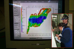
| This image is of the computer display at the end of our survey of the Palmer Deep with the multibeam profiling system. You can see the contouring and beautiful fault controlled basin in the center of the deep, The purple area at the east end of the basin is over 1400 meters deep. The black lines are the track of the ship plotted as it traversed the area. The insert image is of Dr. Amy Laventer and Dr. Eugene Domack looking at a plot of the data to decide where to collect sediment cores Sunday morning. |
 |
|
|
 |