Satellite Image

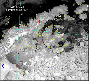
The clear weather yesterday allowed us to get our best satellite image yet. The yellow lines on the image define the actual coastline and some of the major islands. The Antarctic Peninsula shows up beautifully (1) with the highest parts capped by ice. Larsen A area, the area of our initial research (2) shows the open water near the ice shelf (darker gray) and the forming first-year ice, lighter grays. The Larsen Ice shelf (6) shows up as whites and very light grays just to the southwest of the Larsen A area. Robertson Island is visible at the southeastern end of the Larsen Ice Shelf. Prince Gustav Channel (5) is bounded on the west by the Antarctic Peninsula and on the east by James Ross Island (3). Multi year pack ice (4) moving out of the Weddell Sea will soon fill the Larsen A basin and the entrance to Prince Gustav Channel. The red X marks the position of the Nathaniel B. Palmer yesterday at 9:06 GMT when the image was acquired. 5 am 5/25 in the Prince Gustav Channel.
64 01 south, 58 29 west, outside air temp +12 F, 20 mph winds, clear
A beautiful morning here in the Prince Gustav Channel. A half moon is setting in the NW sky and the southern Cross is out in the SW sky. Yesterday was clear all day long and looks like today is shaping up to be a good one too.
We collected cores at various points in the Prince Gustav Channel most of the night and day yesterday and are now getting into position to run some seismic profiles of the channel. The seismic equipment has been having a tough time in the icy conditions we've encountered. The air gun is towed around 30 meters behind the ship and the hydrophone array streams out a couple of hundred meters.
We leave a pretty clear path directly behind us but the broken ice moves back into the channel once the effects of the ship have dissipated. Seals and Minke whales love the channel and play behind the ship in the open water.
A few notes on some of the place names. The Larsen Ice Shelf is named for Captain C.A. Larsen, a Norwegian whaler who sailed along the Larsen Ice Shelf in the Jason as far as 68 10 south during December 1893. James Ross Island was named by the Swedish explorer Otto Nordenskjold in 1903 for James Clark Ross. Ross was the first to see and record the island when he traveled along the eastern side of the Peninsula in 1842. Prince Gustav Channel, also named by Nordenskold, for the Crown Prince and later King of Sweden. Robertson Island was named by Larsen for William Robertson, co-owner of the company that funded his expedition.
Plans are to run seismics for the next 10 hours so we will have a fairly easy shift, unless the equipment fails, then it's back to coring.
Cheers,
Dave
<<May 24 am * May 25 pm >>