 |
|
|
 |
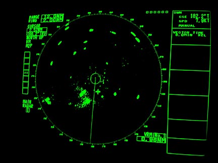
We have yet to see any icebergs visually, but they are all around us and show up really well on the radar. Most appear to be about a mile long, with a couple in the 2-3 mile size. None have been closer than about 4 miles from the ship.
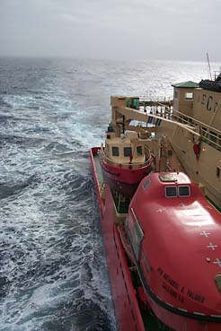
The outside air temperature dropped dramatically overnight. We were averaging around 2.8 C yesterday and now it is down to 0.7 C. With the fog it's hard to see much ahead and the rolling seems more pronounced since you cannot see the swells. However, one can get the feel for their rhythm and be able move about the ship without too much difficulty. The movement is taking its toll however. Only the people who have been to sea before are up and around and working most of the day now.
Green to slight yellow roll zone. Currently we have our "headlights" on. The headlights are two large spotlights mounted above the bridge that light up the area directly in front of the ship. I've been told there are icebergs all around us. About to head up to the bridge and check out the radar.
There is a piece of paper next to the navigation computer titled exactly that and it explains how to read the current speed and the projected distance off the GPS receiver. Below it is a chart that correlates distance and ship speed to total travel time. Additionally on the door of the lab that houses navigation and bottom profiling computers there is a map with a little magnetic boat that is moved to reflect our postion. This isn't anything fancy, every couple of hours one of the women running the navigation computer systems just moves the boat by hand.
The science group and support staff are working into their schedules. The ship operates 24 hours a day. We work 12 hour shifts one group from 8 am to 8 pm and a second group from 8 pm to 8 am. The ships technical support staff also works a 12 hour shift. There is Noon to Midnight shift and Midnight to Noon one.
Almost all scientific operations can be done during the day or night. One of our first projects is to recover some moorings that were put out last year. These will be done during the day because there is a possibilty that while attempting to grappel them they may break free and if the attached floats made it to the surface we could possibly get them.
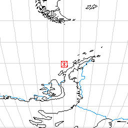
The moorings consist of a 198 kg anchor weight, which has attached to it 390 meters of line. At intervals are plexigalss tubes with funnels attached that collect sediment settling through the water column. At the very top are some floats. Also attached at the top is 800 meters of line that connects to a small anchor that is connected to another small anchor by 200 meters of polypropolene line. The plan is to grapple the 200 meter line between the two anchors and pull the whole arragement on board with the winch. Bottom depth in this area is around 620 meters and the top of the mooring sits aroud 230 meters below the water surface. Our bottom profiling equipment should show the mooring and we will have a sense how the whole thing is sitting on the bottom. At that point the scientists and ship's crew will work out the best direction for the ship to travel to try to hook the 200 meter line with the grappel hook.
Everyone on the ship is getting anxious to get to work. All the equipment is assembled, tested and tested again. There is not much to do until we get to our first station. If this makes you think of kids in a car with "are we there yet?"
We have been recording bottom data all day today. This is done with an acoustic signal sent down to the bottom and then received back at the ship. The time it takes to return is used to calculate the depth to the bottom. The signal is strong enough to penetrate the bottom sediments so we are able to see the layering of the sediments as they have accumulated over thousands of years.
We are also running multi beam bottom profiling which uses an array of sensors wrapped around the hull of the ship. These send out signals and receive the returns. This data is then processed to produce a contour map of the sea floor topography. The width that is mapped is around 3 times the water depth. Not only can the software produce a contour map from this data it can also produce a false 3D image of the seafloor. It's really amazing but we can generate, right on the ship, a 3D view of the ocean floor that we pass over. This is not done in real time though. The data displays a crude wireframe model on the monitor as it comes in but the data needs some heavy processing to produce the maps. The maps are usualy a day behind where we actually are. So I guess we have really good maps of where we've been.
This afternoon we have had quite a following of birds around the ship. They are mainly Cape pigeons and Antarctic petrals. Everyone is anxious for more penguins.
Around 7 pm ship time we saw the first icebergs. We had been seeing them on the radar screen all day long but these we could actually see in the fog. It is hard to imagine what these must have been like for the early explorers in sailing ships. Even knowing they were around us we could not see them. They appear almost instantaneously out of the fog and disappear as quickly. They are almost the same color as the fog and the edges are very hard to define. I can't imagine how the early ships had to proceed at night.
We will cross the Antarctic Circle tonight. I believe a small ceremony is in store for those who have never been across before. I'll let you know what happens. The cook is planning pizza for the midnight meal. Seems this is a tradition of his for the night of the crossing.
Food on the ship is great and plentiful. Lots of fruit and salads, got to keep scurvy at bay. Breakfast the other morning was omlets cooked to order, lunches have ranged from burgers to chicken or spaghetti. Dinners are usually elaborate with fancy chicken, fish or beef, pasta, rice, veggies. There are always cookies or cakes appearing on the counter and whever they run low the trays seem to magically refill.
We are still on schedule for getting to our first science station in the early morning and should be doing our first core of the bottom around breakfast time tomorrow. At this point we are going to do some concentrated mapping to decide where to take the first core of the sea floor. I'll give you all a rundown of that project tomorrow.
Best wishes to all,
Dave
|
|
 |