con12/17/01 1530 hrs.
64 53 S
62 34 W
Cloudy bright, just above freezing, no wind
Well, we made it into Lester Cove around 11:30 this morning after starting to work our way through the ice at 5 a.m. Persistence paid off and with the sun warming the air, the fog and clouds of early morning lifted enough for the crew to confidently move the ship through the ice to the head of Lester Cove. At the head of Lester Cove is the Bagshawe Glacier which is pumping sediment laden water into the ocean where they join. This is exactly the setting Eugene Domack and Dr. Glen Berger were attempting to get to in Brailmont Cove.
The base of the glacier sits well below sea level, and subglacial meltwater conduits enter the ocean at depths up to 435 meters below sea level. Previous work by Eugene suggests a model of multiple tongues of cold sediment laden water extending out into the seawater at various depths in front of the glacier seawater interface.
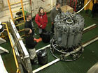
To map and sample these tongues a CTDT instrument package with a rosette of 15 liter sampling bottles is lowered to the bottom. The instruments feed back real time data to a computer on the ship displaying changes in conductivity (salinity), temperature, and transmissivity with depth. The sampling bottles, mounted vertically, are sent down with top and bottom caps open so water simply flows through them on the way down. Once the instrument package and rosette are at or near the bottom and the graphic display of data has been analyzed, the winch is reversed and the unit is brought slowly towards the surface. At points selected based on the CTDT data a signal is sent to the rosette that trips the tensioned top and bottom caps on a given bottle and water from that depth is captured. This process is repeated as needed up through the water column until the whole package arrives on the surface. On deck, each of the bottles can be accessed to provide uncontaminated samples of water from various depths within the water column. Using this device sediment laden plumes were detected by decreases in transmissivity and multiple water samples from within the sediment laden plumes were collected.

A rosette with all bottles tripped returns to the surface with samples collected from various depths. The CTDT instrumentation is contained in the tubular framework below the bottles. (Click image for larger version.)
With successful sample collections with the CTDT rosette, Smith McIntyre grabs, and bottom camera photos we will end the day dragging an underwater video system near the bottom of Lester Cove and Andvord Bay to record some images of the bottom surface as we depart this beautiful area.
Cheers from snowy Andvord Bay
Dave
Caption for photo: The active front of the Bagshawe Glacier at the head of Lester Cove appears with the lifting of morning clouds and fog as we approach station 9.

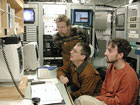
Principal Investigator Dr. Glenn Berger, Chief Scientist Dr. Eugene Domack and Electronics Technician Fred Stuart, watch the data display from the CTDT instrument package as it is lowered next to the face of the Bagshawe Glacier to choose sediment laden plumes to sample as the rosette is returned to the surface. (Click image for larger version.)
Posted December 18, 2001
