 |
|
|
 |
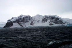 |
Today's photo is of an unammed point on Arrowsmith Peninsula 67 04 South, 66 58 west. Taken before the weather got real bad later this morning. The Arrowsmith Peninsula forms the west side of Lallemand Fjord. According to the tectonic map of south America and the Palmer peninsula the rocks are magmatic arc type. Don't know if it shows in the photos but ther did appear to be some layering near the base of the cliffs. By the time I got the binocs out it was snowing hard enough that I couldn't see them clearly. |
Good morning,
The Palmer Deep is a deep basin in the area off shore from Palmer Station. We are currently doing a carefully layed out zigzag pattern across the area to map the bottom with the multi beam profiler. This will take around 12 hours and calls for some careful coordination between the bridge and the scientists watching the map being produced on the computer.
The pattern consists of a series of parallel lines across the basin with a gentle turn at the end of each to start the next. In order to get a good map there needs to be 10 to 15% overlap of each leg. Any less there is the possibility of the computer not being able to tie the various legs together. If the legs do not overlap there is a hole in the data and a white area left on the map.
In order to be efficient the ship needs to hold to a carefully layed out course. The whole procedure is complicated by the fact that the acoustic signal set out from the ship by the profiler is fan shaped, due to the arrangment of transducers on the hull.
As the water depth increases the width of coverage also increases. The ratio is around three to one. The bottom coverage is three times the water depth. Since this is a basin which is deep in the center and rises on the sides the coverage narrows at the edges of basin and spreads in the middle. The legs are layed out close enough to to map in the shallower water. The deep water just has more overlap of the data between legs.
What makes the Palmer Deep special is the fact that it is deep, greater than 1400 meters. It consists of three basins that trap coastal sediments and biologic material that settles to the bottom. Because it is so deep the sediment that has accumulated in the basin has not been disturbed by icesheets moving off the continent during periods of colder average climate, or by turbulance generated by Antarctic storms.
Eugene Domack of Hamilton College, Amy Laventer of Colgate University and Fiona Taylor of Hamilton College presented a paper last fall on analysis they had completed on an Ocean Drilling Project (ODP) core collected a here last year. The ODP is an on going project to drill long high qulaity cores at various points in the worlds oceans so we can better understand the events that have occured in the past. This core was examined to produce the first ultra high resolution paleo climatic record for the Antarctic.
The base of the core represents the last glacial maximum (LGM) which ended around 12,400 years ago. Working up through the core, examining diatom production and species, magnetics, radiocarbon dates, and oxygen isotope ratios, as well as the general character of the core, they were able to document all the major climatic chages that have been recorded in cores taken in the Northern Hemisphere. This is the first true indication that these were truely global cooling/warming cycles.
Following the survey we will begin multiple coreing operations in this area. I'll keep you informed.
Cheers,
Dave Tewksbury
|
|
 |